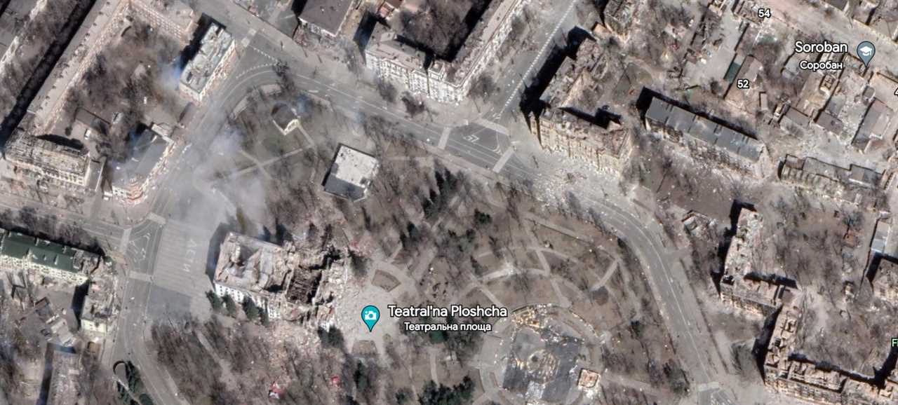
Russia's brutal invasion of Ukraine has lasted more than a year now, and each day brings fresh reports of new horrors from the front lines -- as well as in cities that have been laid to rubble and seen all manner of war crimes and other atrocities. And thanks to newly updated satellite imagery and aerial data, Google Earth is giving people a bird's-eye view of the scale of that destruction and carnage.
Google's tool, which produces a 3D representation of Earth, is reportedly updated once a month or so, but various constraints in some locations can disrupt that cadence. A war presumably counts as one of those interruptions. And while I don't know for sure when these images were updated, social media users in recent days have spotted updated Google Earth photos for the city of Mariupol -- which was one of the first the Russians targeted in the earliest days of the Ukraine invasion.

The Russians reportedly attacked Mariupol with particular savagery, as evidenced in part by the air strike that hit a theater being used as a bomb shelter (which you can see in the image above). That was even though the Russian word for "children" had been clearly written on the ground outside and was visible from the air.
You can still see that word if you note the building to the left of the blue pin above. To the left of that building, you can see the Russian word for children in white letters.
The before-and-after images below, meanwhile, help put that image above into context and illuminate the extent of the bombings and general desolation in the city:
What's more, if you plug the coordinates "47.0927615 37.5526896" into the Google Earth search bar, it will pull up what looks to be a tank in Mariupol, suggesting the satellite and aerial imagery was updated while the fighting was actually in-progress.
According to news reports, weeks of Russian shelling and intense fighting, followed by a siege, led to the surrender of the city in May of 2022. There are estimates that at least 20,000 civilians were killed there.
The post Updated Google Earth images capture the scale of Russia’s destruction in Ukraine appeared first on BGR.
Today's Top Deals
- This $16 clip-on lens kit fits the iPhone or any Android phone, and it’s awesome
- Amazon deal offers a 7-inch Android tablet for under $43
- Save 61% on a 6-port USB rapid charger on Amazon
- Save 75% on a Canon black and white multifunction laser printer on Amazon
Read More
By: Andy Meek
Title: Updated Google Earth images capture the scale of Russia’s destruction in Ukraine
Sourced From: bgr.com/tech/updated-google-earth-images-capture-the-scale-of-russias-destruction-in-ukraine/
Published Date: Wed, 26 Apr 2023 21:45:00 +0000
.png)


